Share
Share
World’s Longest Heated Pipeline
Oil wells in the national park
Total will soon produce oil in Uganda in areas inhabited by elephants and giraffes. And that may be just the beginning. Here is our visual investigation.
The plates
Just below the earth’s crust lies a tumult, as currents of magma ceaselessly tear at the tectonic plates that make up its thin surface. The African continent is being torn apart. About 20 million years ago, a huge crack was formed.
The crack
Magma surged upward, and mountains rose up on either side of the crack, with Mount Kenya and Kilimanjaro on the eastern part of the rift valley, and the Rwenzori Mountains on the west. In between, where the earth sank, lakes were formed. Examples include Lake Tanganyika, one of the deepest in the world, as well as Lake Edward and Lake Albert.
The sediment
At the bottom of Lake Albert lies treasure – plant and animal remains that sank to the bottom thousands of years ago. The Rift Valley, as researchers call the trench, enabled an easy transformation of the organic remains into oil and gas. All it took was pressure, time and temperatures of between 80 to 120 degrees. At the edges of the trench, the gas and oil then made their way back toward the earth’s surface until they encountered impermeable rock and could go no further.
The discovery
Image: BBC Natural History via Gettyimages
Conjectures that had been made after drilling in the 1990s were confirmed in 2006 – 6.5 billion barrels of oil lay beneath the earth. Between 1.2 to 1.7 billion are considered accessible.
Distribution battles
The battle for drilling rights began soon after. The British-Irish company Tullow Oil had discovered oil in one of the exploration areas in 2006, and Heritage Oil also owned shares. Tullow paid off Heritage, selling two-thirds of its shares to France’s Total and China’s China National Offshore Oil Corporation (CNOOC). In 2020, Total bought the remaining Tullow shares. 56.67 percent of the areas are now owned by Total, 15 percent by Uganda National Oil and 28.33 by CNOOC. Total operates the Tilenga production area and CNOOC is in charge of Kingfisher.
The sea
So far, there is no significant oil production in Uganda because there is also little demand for the raw material. Uganda is one of the poorest countries in the world. Not many people have cars, most use bicycles and motorbike taxis. And because the country is landlocked and such vast quantities of oil cannot be transported by trucks, Total, CNOOC and the governments of Uganda and Tanzania are building the EACOP pipeline. The oil here, however, is viscous and would require pumping stations every few hundred kilometres to ensure that it doesn’t stop. That’s why the world’s longest heated crude oil pipeline is being built with the nearest oil terminal 1443 kilometres away in Tanga, Tanzania.
Gold rush

There are reasons why oil companies have chosen Uganda. The country, with its 41 million inhabitants, is one of the more stable in the region. In the neighbouring Democratic Republic of Congo, warlords and Ebola outbreaks have driven an estimated four million people to flee, and Uganda continues to absorb most of them. Rwanda is finally at peace after the genocide, but only because a questionable police state enforces it.

Uganda itself has suffered from civil wars and massacres since 1970; in the 1970s alone, dictator Idi Amin killed 300,000 opposition members and civil war raged in the north until the 2000s. President Yoweri Kaguta Museveni has been in office since 1986 and is determined to stay there with all his might.

The day before his last re-election in January 2021, the government blocked all important social media platforms. Opposition candidate Bobi Wine was arrested several times, and international election observers reported serious shortcomings. Compared to South Sudan and Congo next door, the country is nevertheless considered stable by many investors. The economy has been growing for several years - but at a very low level.

According to the UN Development Index, Uganda ranks 159 out of 189, the gross domestic product is just 822 dollars per capita, and almost 70 percent work in agriculture. Climate change is increasingly threatening harvests. In 2019, only 48 percent of children had their own blanket to sleep with.

Houses in Uganda are mostly self-constructed, 40 percent of the people live from subsistence farming.

The president blames the people themselves for their poverty. In several speeches, he calls them lazy and dishonest.

However, he assures the very same people that the oil will help the country to prosper. The state owns 15 percent of the project through the newly created Uganda National Oil Company. According to a spokeswoman, the Petrol Authority of Uganda (PAU) expects annual oil profits of 1.4 to 2.9 billion euros. By comparison, the total state budget of Uganda 20/21 was 11.8 billion euros. In addition, there would be tax revenues and positive effects for other industries, she says. One hundred and sixty thousand jobs are expected to be created and a small refinery will process 60,000 barrels per day to cover national needs. That’s a miniscule amount compared to the 2.1 million barrels consumed in Germany per day. But according to the spokeswoman, the 60,000 barrels will cover the entire demand for paraffin, diesel and petrol in Uganda in the future. It’s easy for the president to tout the pipeline as an opportunity.

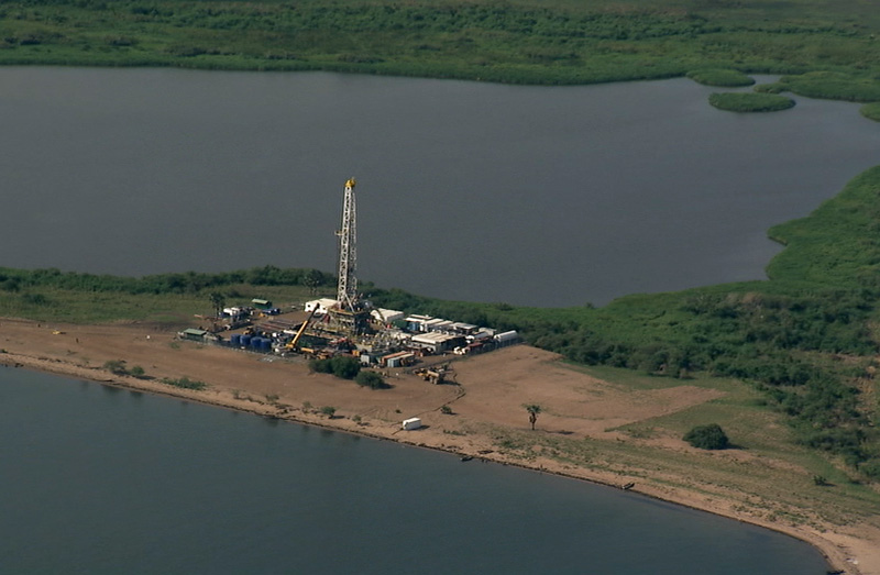
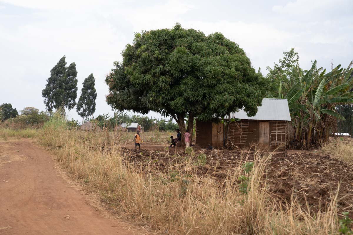
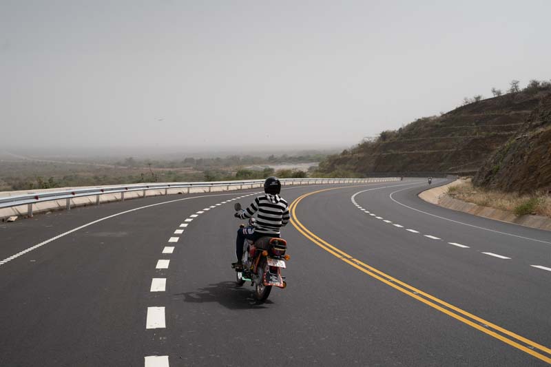
But there is a problem- the area is not vacant. There are people living there, mostly from agriculture, as well as some very rare animals.

What does it mean to build oil production from scratch in such an area? Satellite images, 3D models of the area and precise data of the planned infrastructure provide an idea.

Most roads in the country are unpaved.
Some are now being modernised for the oil.
The mining area
There are two main mining areas: Tilenga, named after a local antelope, and Kingfisher, named after a rare bird. Tilenga is operated by TotalEnergies and will soon output an estimated 190,000 barrels per day. Kingfisher is under development by CNOOC and is scheduled to produce 40,000 barrels a day.
Kingfisher
From the adjacent hill, the scale of the Kingfisher project is already visible with its workers’ camp huts and long improvised air­strip. Oil wells are being drilled into some of the already levelled areas. The oil is then pumped through infield pipelines to the Central Processing Facility (CPF), where it is separated from impurities and gases, and from the water used to squeeze it out of the ground. A feeder pipeline brings the oil to the industrial area, where it is collected.
The hub
From the industrial area, the oil is sent at walking pace on its 1443-kilometre journey and always kept at between 50 to 70 degrees. A national refinery is also being built in the industrial area. From here, a second 95-kilometre pipeline will transport refined fuel to a storage terminal near the capital Kampala. From the industrial area, the oil is sent at walking pace on its 1443-kilometre journey and always kept at between 50 to 70 degrees. A national refinery is also being built in the industrial area. From here, a second 95-kilometre pipeline will transport refined fuel to a storage terminal near the capital Kampala.
The airport
In the middle of it all, an international airport is being built, more modern than the capital’s Entebbe airport. This should make it easier to bring in materials and skilled workers. The government is building it with the Swiss construction company SBI International Holdings and the British Colas UK. The runway already exists. It is three and a half kilometres long and stable enough for the world’s largest cargo planes. Satellite images over time show how forests and farmers’ fields have been bulldozed for the airport. Entire villages have been relocated. In the middle of it all, an international airport is being built, more modern than the capital’s Entebbe airport. This should make it easier to bring in materials and skilled workers. The government is building it with the Swiss construction company SBI International Holdings and the British Colas UK. The runway already exists. It is three and a half kilometres long and stable enough for the world’s largest cargo planes. Satellite images over time show how forests and farmers’ fields have been bulldozed for the airport. Entire villages have been relocated.
A strategic location
Whether such an airport is necessary just to produce oil is questionable. The airport, however, is in a strategic position, close to the borders with the Democratic Republic of Congo (DRC), South Sudan and Rwanda. Uganda already has military air supremacy in the region. Ugandan troops have long been marching into the DRC for “peacekeeping missions”. They are commanded by the son of the Ugandan president, Muhoozi Kainerugaba. He wants to replace his father as president in the next election and recently spoke out in favour of Putin. The DRC is one of the most mineral-rich areas in the world. Seventy percent of the world’s coltan, an ore essential for electric car batteries, is extracted there. The. In addition, the crisis region is one of the most important exporters of gold.
Tilenga
Further north, the water from Lake Albert continues to flow into the White Nile. From there, it flows through South Sudan and Sudan until it reaches the Mediterranean Sea. Here, at the northern tip of Lake Albert, the site of Total’s Tilenga project, 426 boreholes will soon be drilled. Two hundred of these boreholes alone will be used to pump the large amounts of water into the ground necessary to get out the oil. From the wells, fitted together in drill well pads, the oil is to be pumped underground through infield pipelines to the CPF. There, it will be pumped through a feeder pipeline to the beginning of the EACOP.
The garden
The fact that there are few people living in parts of the Tilenga production area and in need of relocation stems from one simple reason: the area is mostly inhabited by animals. It is the largest and oldest national park in the country, the Murchison Falls National Park.
Paradise under threat

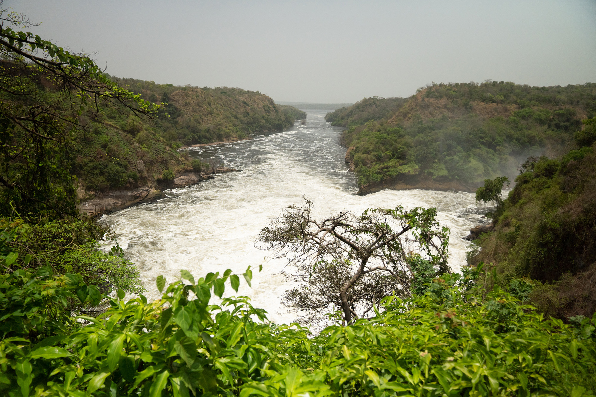
Murchison Falls was named after the chairman of the British Royal Geographical Society, just as many places in East Africa are named after former conquerors and colonial rulers. In 1952, the rulers designated the area as Uganda’s first national park. Today it covers more than 3800 square kilometres.

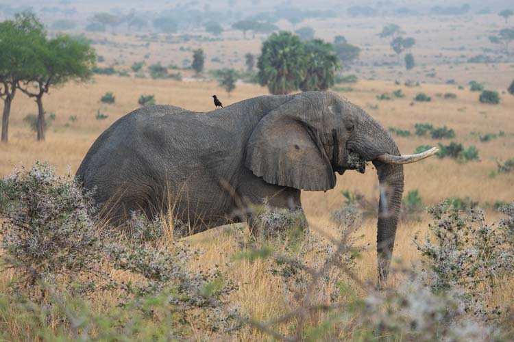
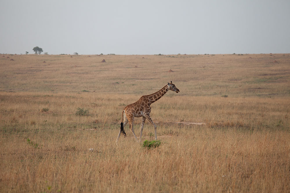
The fact that it is one of the country’s most important tourist attractions is not only due to its mighty waterfalls, but also to its biodiversity. More than 2700 African elephants, lions, leopards, monkeys, giraffes, hippos and antelopes live here - 76 different mammal species in total. This evolving landscape of the Nile, with its savannas, trees and wetlands, is also home to 451 bird species. Many of them are considered endangered.

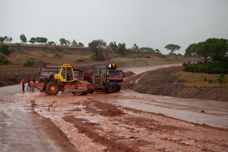
In the midst of buffalo herds, flocks of birds and gymnastic monkeys, roads are now being widened. Huge construction machines plough the landscape.

Murchison Falls National Park alternates between wetlands, savannas and forests. These landscapes provide a habitat for giraffes, leopards and many antelope species, among others.
The bridge
Oil production infrastructure is heavy and large. Even before the oil is pumped out of the park, it has already changed it forever. In order to transport material and workers more efficiently, a bridge was built in the national park. Previously, vehicles could only cross here with a small ferry.
The logistics
To get through the park faster, the biggest road here has been paved. Officials say the roads improve the country’s infrastructure. Environmental groups say they could deter animals from traversing the national parks. The government is building a total of 13 so-called Critical Oil Roads to facilitate the project, many on credit. China, for example, is financing three.
Not an isolated case
Murchison Falls is not the only nature reserve affected by oil. Right next to it, is the Budongo Forest, home to one of the largest groups of chimpanzees in the world. A road also runs through the foothills of this forest.
Protected areas
Nature and landscape conservation areas skirt the entire pipeline. Some of them are Ramsar protected sites. These are wetlands of international importance, habitats for waterfowl and wading birds, for example. And, within a short distance of the end of the pipeline where the oil is shipped, lies a coral reef.
The displaced
Much of the remaining land for the project belongs to the people, as does most of the land in Uganda. They either farm for self-sufficiency, as do 40 percent of the people in the country, or grow coffee, cotton or sugar cane, for example. For the oil, people are displaced and either resettled or compensated. One of them is Jelousy Mugisha. He claims the compensation offered was not fair, he was given far too little for his house. Mugisha is still fighting in court today. You can read accounts from him and other people who were displaced in this report.
The dispossessed
Most of those dispossessed do not have to give up their house, but parts of their land. They are only compensated, however, for the strip of land on which the pipeline runs. How many people are affected is disputed and documents usually only speak of Project Affected Persons (PAPs). According to international rules, as Total confirmed when asked, a PAP can be an entire household. Government and company documents show 25,665 PAPs in the various regions. The World Bank, when asked, also says that PAPs in this case are probably just the heads of households and businesses. Several NGOs estimate the number of affected individuals to be between 80,000 to 116,000 people, rather than 25,665.
The risk

Along tectonic rifts, tension regularly results in discharges at the many fractures from plate displacements. Since 2002, there have been dozens of earthquakes reaching 4.5 and above on the Richter scale. The largely underground oil pipeline is therefore being reinforced in some places. Sensors are supposed to detect leaks immediately. The Petroleum Authority of Uganda cites possible leaks as the greatest risk that oil activities pose to the country. All technical measures have therefore been taken to minimise the risk. In the event that leaks do occur, it is important as a country to develop contingency plans, laws and measures.

In addition to the risk of earthquakes, there are increasingly frequent heavy rains that trigger floods and landslides – extreme weather events caused by the climate crisis. And this is mainly driven by the burning of fossil fuels.

Only the beginning?

An important fact is being ignored in European climate debates about electric cars and green energy: global oil consumption is rising. The growing middle class in China is buying up cars, as are those in India and some African countries.

In Germany, more and more people may be switching to public or electric cars, but the old combustion engine cars are still being sold, especially to Africa. Here, they continue to drive them for years, with the high petrol consumption of yesteryear. The sales figures for new German cars have also risen instead of falling in recent decades. These cars are simply no longer driven in Germany.

Unsurprisingly, most oil companies predict that oil consumption will rise or remain at the same level in the next ten years. Russia, one of Europe’s largest oil suppliers until recently, is reorganising supply chains since the invasion of Ukraine. This increases the pressure to open up new production areas.

The oil deposit at Lake Albert is actually small when compared to the oil fields found in Saudi Arabia, Norway or the USA. In addition, one can never say exactly whether as much of the deposits can really be extracted as predicted. As soon as one looks at the map, it becomes clear why the EACOP mega-project could be so momentous for Uganda, as well as for the African continent and even the whole world.

Climate change has long since altered Lake Albert. After heavy rains two years ago, the lake overflowed its banks here and never withdrew.
Where next?
A pipeline like EACOP, which costs billions, is a bit like a motorway connection. Once the pipeline is in place, it becomes cheaper to extract more oil nearby. And no matter who is producing, everyone will have to pay a fee to the owner- in this case Total and to a lesser extent CNOOC, Uganda and Tanzania. It is clear that there are other oil deposits around Lake Albert – in the Virunga National Park in the Democratic Republic of Congo, for example, which is known for its population of gorillas. Or in Rwanda. Uganda’s President Museveni has already expressed his wish to connect neighbouring countries to the pipeline.
The expansion
There is no end in sight. This map shows all the areas currently designated for oil and gas exploration in Africa. Only a few are already in operation.. The rest are neatly divided in perfectly straight lines. Some are owned by small companies and others already bought by the big ones. The exploration, buyouts, distribution battles and extraction deals continue. Some affect the last green oases on the planet and change the lives of defenceless people whose land is being taken away in exchange for a pittance.

This article is part of a year-long research project on the consequences of climate change in severely affected regions of Africa. The main focus is on female climate activists who are trying to highlight problems and find solutions on the ground. All previous articles from the series can be found on the project page. The research project is funded by the European Journalism Centre under the European Development Journalism Grants Programme. This programme is supported by the Bill & Melinda Gates Foundation.

For this article, we especially thank Stefan Back from RWTH Aachen University, who shared his geological knowledge with us. Furthermore, we thank Bart Wickel from Earth Insight and the Austrian Company EOX, who kindly allowed us to use their carefully processed Sentinel sattelite imagery.

Datenquellen
Where does the data come from?

Sattelite images: Sentinel-2 cloudless - https://s2maps.eu by EOX IT Services GmbH (Contains modified Copernicus Sentinel data 2020)

Sattelite images of the airport: Image Landsat / Copernicus und Sentinel-2 via Google Earth Pro and Google Earth Engine

Tectonic Plates: Peter Bird „Geochemistry Geophysics Geosystems, 4(3), 1027“ via Hugo Ahlenius/Nordpil

Pipeline and infrastructure: Petroleum Authority of Uganda

Tectonic fault lines: British Geological Survey via data.gov.uk

Oil exploration and production areas: oilmap.xyz via Map for Environment

Oil and gas fields: Energy Data Exchange’s Global Oil and Gas Features Database via ArcGIS

Project Affected People: Resettlement Action Plan EACOP Uganda, Resettlement Action Plan EACOP Tansania, Resettlement Action Plan Tilenga, Resettlement Action Plan Kingfisher, Resettlement Action Plan Kabaale

Protected areas: UNEP World Conservation Monitoring Centre’s World Databank on Protected Areas

Earthquakes: Earthquake Calalog/USGS

Female Climate Activists in Africa
About the Project

The Project

This article is part of a year-long research project on the consequences of climate change in severely affected regions of Africa. The main focus is on female climate activists who are trying to highlight problems and find solutions on the ground.

The global climate movement is shaped by young women. In this country, activists like Greta Thunberg from Sweden are in the foreground - or Luisa Neubauer, the German face of “Fridays for Future”. Their female campaigners from Africa are often overlooked, yet their countries are already much more affected by the climate crisis.

Through the project A Female Fight for the Future, the Tagesspiegel accompanies female climate activists in African countries. We look at their projects to fight climate change on the ground, but also at their attempts to put pressure on international politics through global networks. The project also visualizes the effects climate change already has on African regions – and the driving ecological change.

All previous articles from the series can be found on the project page.

Funding

The research project is funded by the European Journalism Centre under the European Development Journalism Grants Programme. This programme is supported by the Bill & Melinda Gates Foundation.

The Team

Eric Beltermann
Web Development
Benedikt Brandhofer
Art Direction
Nina Breher
Research and Coordination
Cordula Eubel
Research
Tamara Flemisch
Web Development
Raphael Khouri
Translation
Hendrik Lehmann
Text, Research, Photos, Concept
David Meidinger
Web Development
Published 10 June 2022.
Last updated 9 March 2022.